Drone technology developed at KAUST helps locate wandering camels, map herd movements
JEDDAH: As Saudi Arabia accelerates the adoption of advanced technologies across key sectors, researchers are harnessing artificial intelligence and drone technology to modernize one of the Kingdom’s oldest traditions: camel herding.
Home to more than 2.1 million camels and over 80,000 owners, Saudi Arabia’s camel sector remains deeply rooted in the Kingdom’s cultural identity and rural economy. Yet managing herds across vast desert landscapes presents enduring challenges, including livestock loss, overgrazing, road accidents involving stray animals, and the difficulty of monitoring herds in remote areas with limited communications infrastructure.
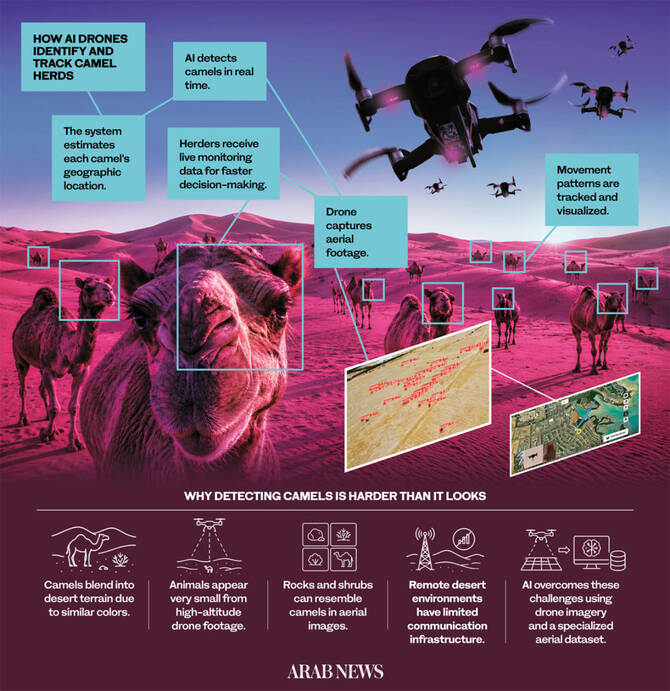
To help address these issues, researchers at King Abdullah University of Science and Technology have developed an AI-powered drone system capable of detecting, identifying and tracking camels in real time. The technology is designed to help herders manage livestock more efficiently while improving safety, reducing costs and promoting more sustainable grazing practices.
The project was developed in response to the practical realities of herding in remote desert environments, where monitoring animals across expansive terrain is both labor-intensive and costly. Designed as a low-cost solution, the system uses a small civilian drone equipped with a single camera, eliminating the need for expensive equipment or complex communication networks.

Speaking to Arab News, Dr. Basem Shihada, a computer science professor at KAUST, said developing the system required overcoming several technical hurdles.
“One of the most significant challenges was detecting camels from high altitudes using only a single camera,” he said.
He added that the limited coverage area of an individual drone also posed a challenge, requiring the research team to develop innovative approaches to ensure reliable monitoring across large desert landscapes.
At the heart of the system is a YOLO-based AI model trained on what researchers describe as the first aerial dataset of camel images of its kind. The model enables drones to detect camels in real time, even when the animals appear small in aerial footage or blend into the surrounding desert terrain.

Using bounding boxes superimposed on live aerial video, the system can accurately identify and locate individual camels while continuously tracking their movements.
Beyond simple detection, the platform provides real-time insights into grazing behavior by mapping herd movements and travel routes. The data enables herders and researchers to better understand herd distribution, movement patterns, travel directions and periods of activity—information that has traditionally been difficult to gather across vast desert environments.
Researchers believe the technology could help reduce livestock losses, prevent road accidents involving stray camels and improve grazing management, all while lowering operational costs for herders.
“It can reduce traffic accidents caused by stray camels, improve pasture management, boost production efficiency, and safeguard livestock,” Shihada said.
The system also provides researchers with a valuable tool for studying camel behavior in their natural habitat. The data collected could support the development of more effective herd management strategies and improve animal welfare practices.
To build the technology, the research team collected aerial images of camel herds across Saudi Arabia using a drone-mounted camera before training the AI model through machine-learning techniques. The model learned to distinguish camels from visually similar desert features such as rocks and shrubs, enabling accurate detection under challenging environmental conditions.
Shihada said the search for an alternative to Global Positioning System collars was driven by the realities of operating in remote desert regions.
Traditional terrestrial communication networks and electricity infrastructure are often unavailable in such areas, while satellite-based solutions can be costly and suffer from high latency, he explained.

“Other existing solutions, such as applying GPS collars onto camels or using satellite imaging, are not feasible in resource-constrained desert environments. Thus, utilizing UAVs to establish a non-terrestrial wireless communication system between camels and herders during grazing is more sustainable and cost-effective,” Shihada said.
Beyond its practical applications, the project underscores the potential for Saudi-developed AI technologies to address challenges unique to the Kingdom’s environment, economy and cultural heritage.
“Our camel monitoring project demonstrates that meaningful AI innovation doesn’t have to originate from global tech hubs. Camels are central to Saudi heritage, and the desert environment presents monitoring challenges — scale, terrain, heat — that generic solutions weren’t build for. By developing drone and AI systems tailored to these conditions, we prove that Saudi researchers can build context-aware tools for problems unique to the Kingdom.
“This capability can be extended to broader wildlife and environmental monitoring, establishing a foundation for homegrown AI that serves Saudi needs rather than adapting foreign solutions to fit them.”
Looking ahead, the research team plans to expand the system by deploying coordinated fleets of drones, improving positioning accuracy and integrating non-terrestrial communication technologies to provide continuous coverage across open desert landscapes.
The technology’s potential extends beyond camel herding. KAUST has already entered into an agreement with African Parks and acquired a wildlife dataset from Africa that will be used to train AI models capable of detecting and monitoring a wide range of animal species across diverse environments.
Source : https://www.arabnews.jp/en/business/article_173866/